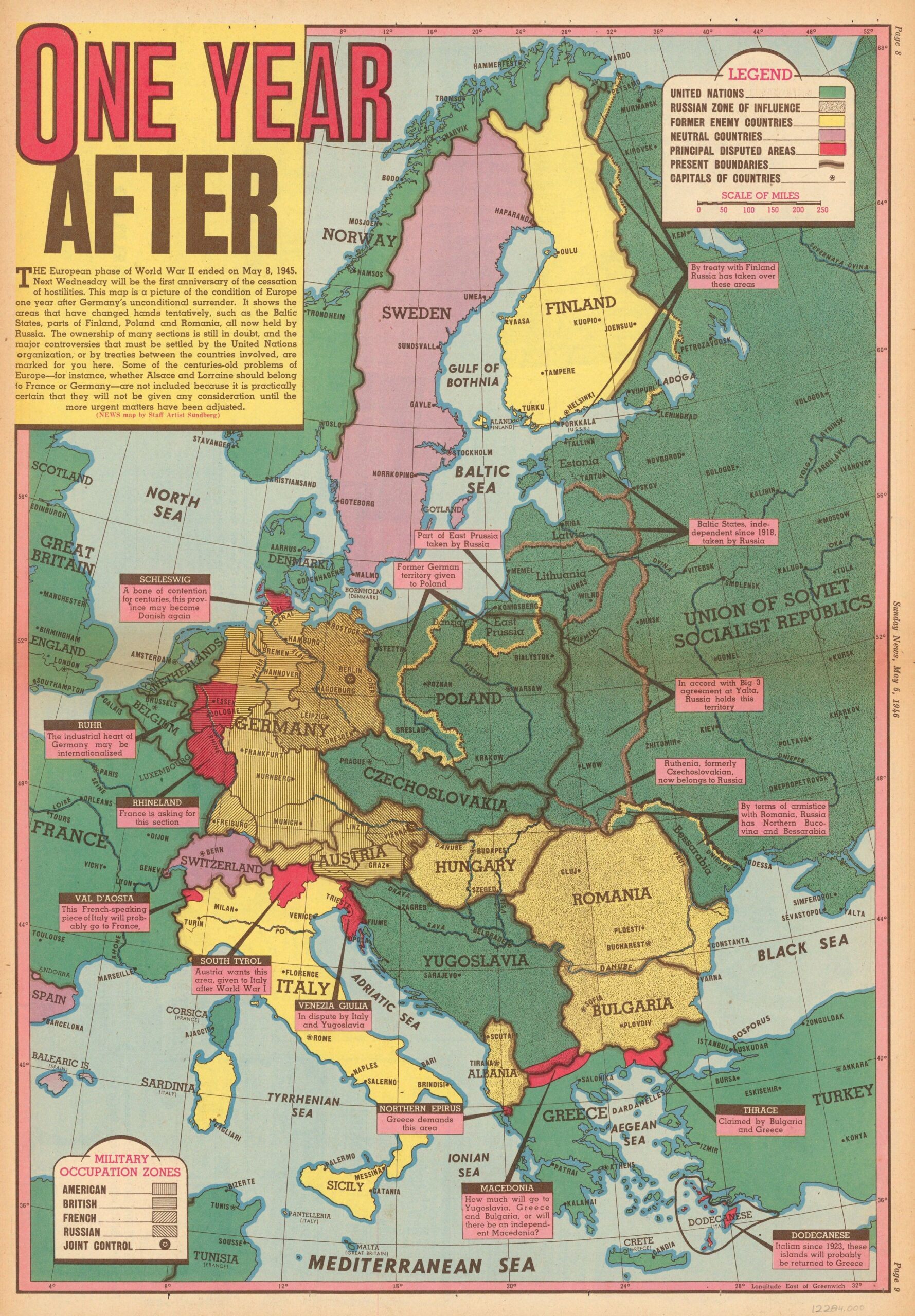
This map was created by Edwin L. Sundberg and published in the American weekly newspaper. Sunday News 5 May 1946, one day before the first anniversary of the end of the Second World War in Europe.
The colours in the illustration seek to show the importance and weight of the newly created United Nations, with all member countries marked in green. Countries that remained neutral during the conflict (Switzerland, Sweden, Spain and Andorra) are shown in purple, and states that were enemies and had not yet joined the United Nations are shown in yellow. Most of them would do so nine years later, in 1955.
The areas that were still in dispute at the time, with no clear idea of what the final outcome would be, are marked in red:
- Dodecanese archipelagoThis group of 15 islands was part of Italy during the Second World War and in 1946 they were still a protectorate of the United Kingdom. In 1947 they became part of Greece.
- Western ThraceThis region was occupied by Bulgaria during the Second World War. In the end, Bulgaria maintained its territorial claim, but it eventually became Greek territory once again.
- MacedoniaThis area became a puppet state of Germany in 1944 and, despite its brief existence, there were talks about creating an independent state after the Second World War, which ultimately came to nothing.
- Venice JuliaThis region was disputed by Italy and Yugoslavia after the end of the Second World War. In 1947, it was decided that the western part would become part of Italy and the eastern part part of Yugoslavia, leaving the city of Trieste as a free city state. In 1954, Trieste became part of Italy.
- South TyrolThis region, which became part of Italy after the First World War, was the subject of several proposals. It was finally decided that it would remain part of Italy, provided that the German-speaking population was granted a high degree of autonomy.
- Aosta Valley: France occupied this valley during the Second World War and attempted to maintain control after the war ended. Pressure from the United States and the United Kingdom eventually led to the territory being returned to Italy.
- RhinelandAfter the end of the Second World War, France claimed this territory, but it was determined that it would remain part of West Germany.
- Ruhr regionDuring the Second World War, this region was occupied by the Americans and British. As it was the industrial heartland of Germany, the possibility of establishing an international zone was considered, but it ultimately became part of West Germany.
- SchleswigIt was proposed that this region should become part of Denmark, as it had been historically, but in the end it was decided that it should remain part of West Germany.
The map also details other territorial changes that were already finalised, such as the parts of Finland, the Baltic States and parts of Poland that became part of the Soviet Union.
Sources

