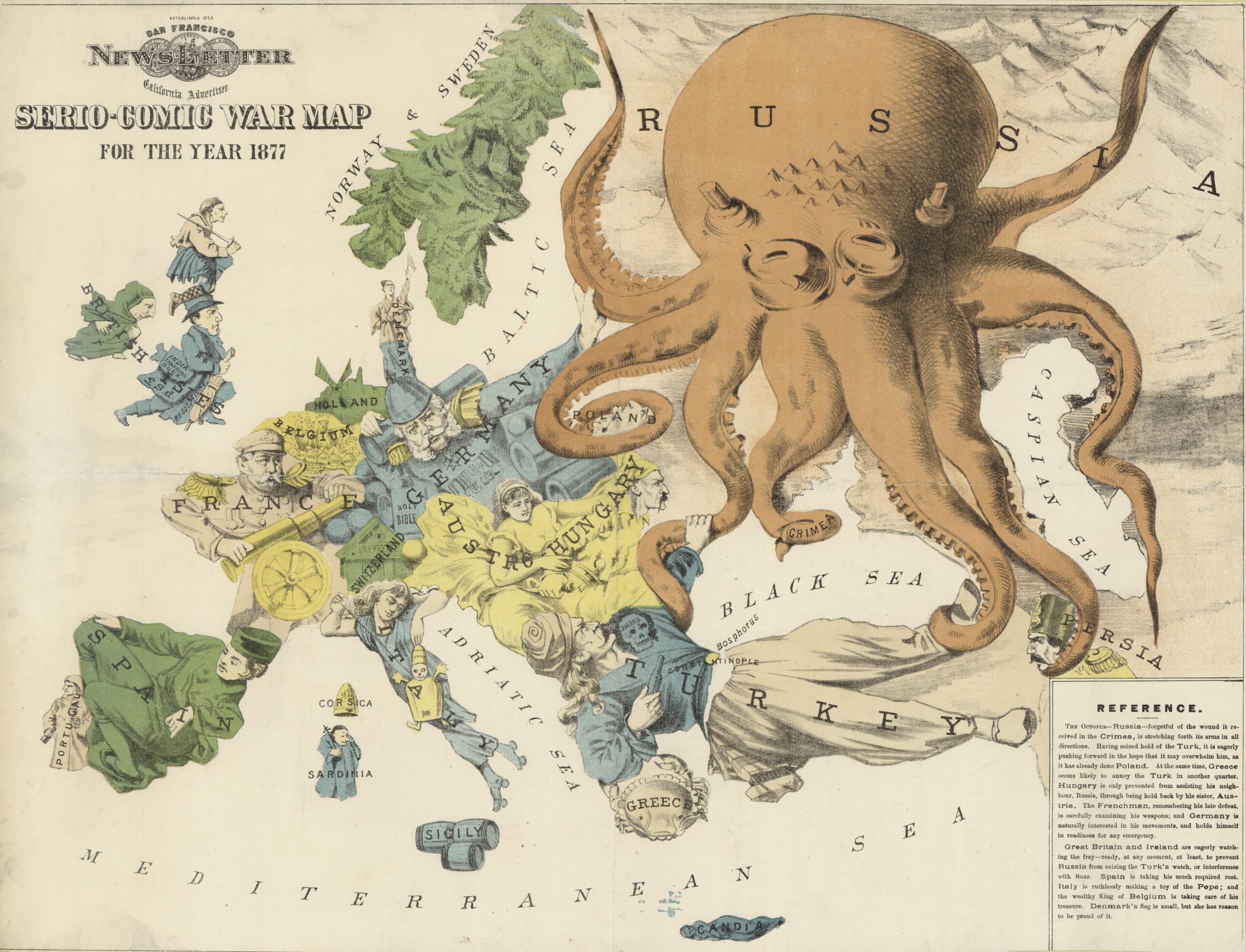
This map was drawn by the British cartoonist Fred W. Rose in March 1877. With a satirical and, to a certain extent, propagandistic character, Fred W. Rose depicts the political situation in Europe, one month before the outbreak of war between Russia and the Ottoman Empire.
Titled Serious-Comic War Map (Satirical War Map), this map is Rose's crowning work. In it, Rose chooses to translate his caricatures onto a map of Europe, thereby adding a layer of narrative to the cartography which, although it had been used before, had never reached this level of complexity:
- The Russian Empire is depicted with the iconic octopus. Its tentacles are strangling Persia and Poland, but are also grasping the Ottoman Empire.
- The Ottoman Empire defends himself with a pistol from the Russian Empire.
- Greece is a small crab that is pinching the left arm of the Ottoman Empire.
- The Austro-Hungarian Empire is represented by two figures: Austria as a woman holding Hungary, a man, so that it does not attack Russia.
- Germany is personified in the figure of Otto von Bismarck, who is surrounded by armaments and holds up the Russian Empire with his left arm.
- Italy She appears as a relaxed young woman, a reflection of the recent unification of the country.
- Spain appears relaxed and sleeping with its back to the rest of Europe.
- France is personified in the figure of Marshal MacMahon, who is aiming his artillery at Germany, seeking revenge for the defeat in the Franco-Prussian war.
- The British Isles, The figures of an English knight, a Scottish highlander and an Irish monk, depicted as an English knight, a Scottish highlander and an Irish monk, are attentive to events in the rest of Europe and ready to intervene.
This map enjoyed great popularity throughout Europe and had multiple reproductions, adaptations and even translations into other languages. Its cultural and artistic imprint is tangible in the many maps that later also used an octopus as a figure of oppression on a map. More examples can be found at this monograph.
Sources

