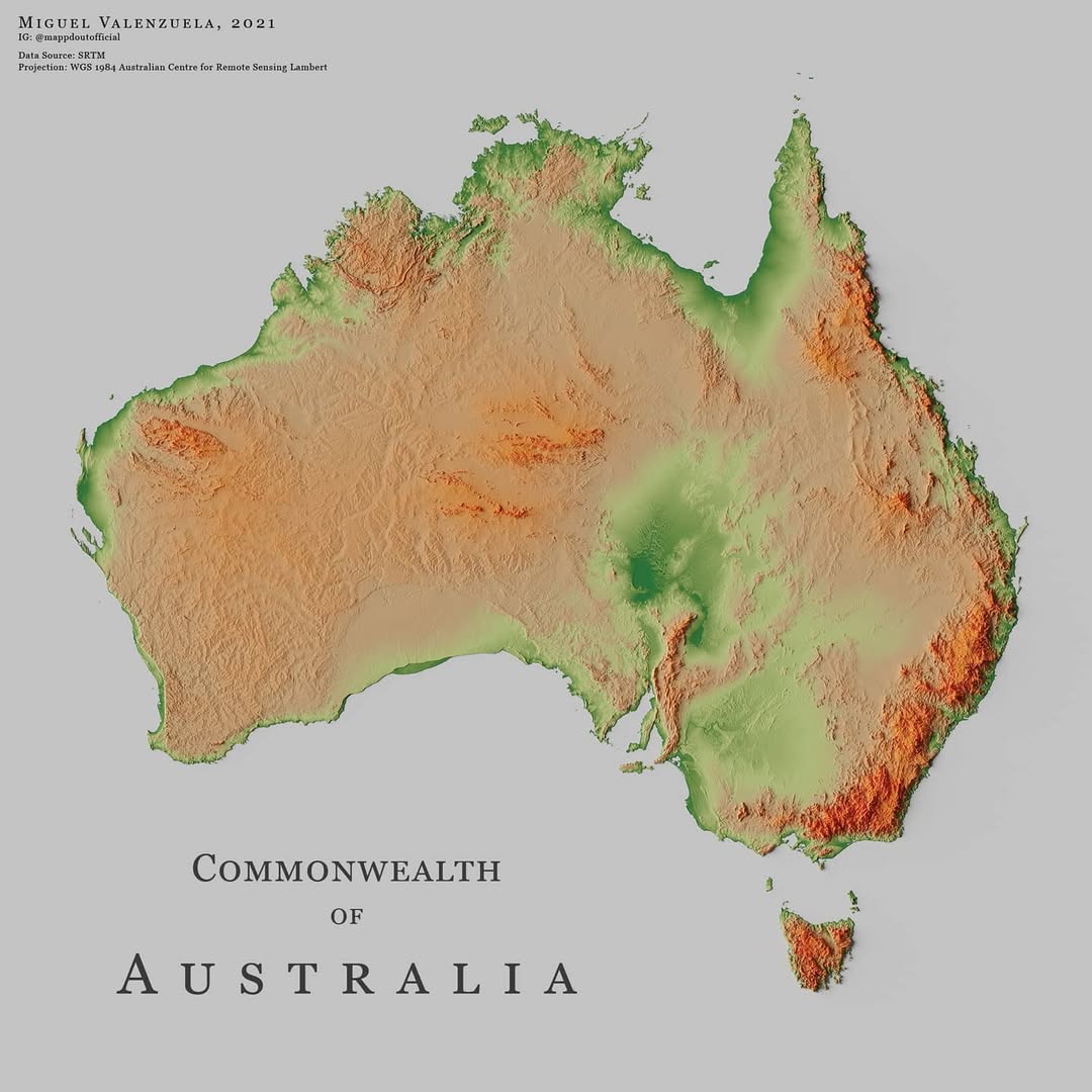
This map, created by Miguel Valenzuela, shows the relief of Australia. It uses three colours: green for the most important areas, green for the...
Relief map maps

Relief map of France, by Miguel Valenzuela (2020)
This map, created by Miguel Valenzuela, shows the relief of France. It uses two colours: blue for the more mountainous areas and blue for the...

Relief map of Vietnam, by Miguel Valenzuela (2021)
This map, created by Miguel Valenzuela, shows the relief of Vietnam. It uses two colours: red for the more rugged areas and red for the...

Relief map of Iraq, by Miguel Valenzuela (2023)
This map, created by Miguel Valenzuela, shows the relief of Iraq. It uses three colours: blue for areas covered by...

Relief map of Burundi (2023)
This map was created by Peter Atwood in 2023 as part of the #30DayMapChallenge initiative. It is a relief map of...

Relief map of Pakistan, by Miguel Valenzuela (2021)
This map, created by Miguel Valenzuela, shows the relief of Pakistan. It uses two colours: green for low-lying areas...

Relief map of Nepal, by Miguel Valenzuela (2023)
This map, created by Miguel Valenzuela, shows the relief of Nepal. It uses three colours: turquoise for low-lying areas,...

Relief map of Taiwan, by Miguel Valenzuela (2021)
This map, created by Miguel Valenzuela, shows the relief of Taiwan. It uses two colours: blue for low-lying areas...

Relief map of Austria, by Miguel Valenzuela (2021)
This map, created by Miguel Valenzuela, shows the relief of Austria. It uses two colours: red for low-lying areas...

Relief map of Sweden, by Miguel Valenzuela (2021)
This map, created by Miguel Valenzuela, shows the relief of Sweden. It uses two colours: blue for low-lying areas...

Relief map of Bangladesh, by Miguel Valenzuela (2021)
This map, created by Miguel Valenzuela, shows the relief of Bangladesh. It uses two colours: dark green for areas...

Relief map of Canada, by Miguel Valenzuela (2021)
This map, created by Miguel Valenzuela, shows the relief of Canada. It uses two colours: red for low-lying areas...

Relief map of Azerbaijan, by Miguel Valenzuela (2021)
This map, created by Miguel Valenzuela, shows the relief of Azerbaijan. It uses three colours: green for low-lying areas,...

Relief map of Turkey, by Miguel Valenzuela (2021)
This map, created by Miguel Valenzuela, shows the relief of Turkey. It uses three colours: red for low-lying areas,...

Relief map of Ethiopia, by Miguel Valenzuela (2021)
This map, created by Miguel Valenzuela, shows the relief of Ethiopia. It uses two colours: green for low-lying areas...

Relief map of Switzerland, by Miguel Valenzuela (2021)
This map, created by Miguel Valenzuela, shows the relief of Switzerland. It uses three colours: black for low-lying areas,...

Map of Dominica (1775)
This map, created by Thomas Jefferys, is part of his posthumous work The West-India Atlas...

Relief map of Iran, by Miguel Valenzuela (2021)
This map, created by Miguel Valenzuela, shows the relief of Iran. It uses three colours: green for low-lying areas,...

Relief map of Portugal, by Miguel Valenzuela (2021)
This map, created by Miguel Valenzuela, shows the relief of Portugal. To do this, it uses different shades of red: dark...
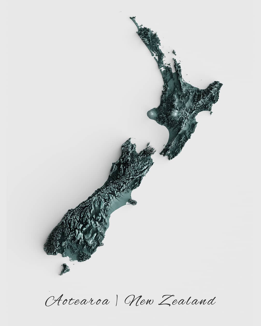
Relief map of New Zealand, by Miguel Valenzuela (2020)
This map, created by Miguel Valenzuela, shows the relief of New Zealand. To do this, it uses different shades of silver:…
 Español
  English (UK)